You are not just buying a house on Lake Mendota. You are buying a shoreline, a slice of water access, and a set of rules that shape how you can use both. If you understand riparian rights early, you avoid costly surprises and plan your lake lifestyle with confidence. In this guide, you will learn how riparian rights work in Wisconsin, what the ordinary high-water mark means, which permits apply on Lake Mendota, and the steps to take before you write an offer. Let’s dive in.
What riparian rights mean on Mendota
Riparian rights are the special rights that come with owning property next to a navigable lake. In Wisconsin, these rights typically include reasonable access to the water, the ability to place a dock or pier, and the use of the shore area in line with state and local rules. These rights come with limits that protect public use and the environment. Understanding those limits helps you plan docks, shoreline upgrades, and long-term maintenance the right way.
Public trust and navigability in Wisconsin
Wisconsin follows the public trust doctrine for navigable waters. The state holds the beds of navigable waters in trust for the public, which preserves public use of the water surface for navigation and fishing. Your private ownership usually extends to the ordinary high-water mark, not into the lakebed below that line. The result is a balance between private shoreline use and public water use.
The ordinary high-water mark (OHWM)
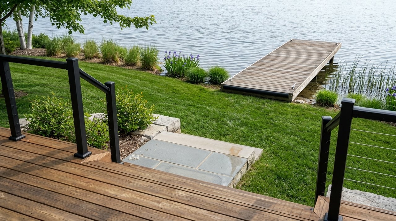
The OHWM is the legal boundary that often separates your private upland from the state-owned lakebed. The exact location matters for docks and shoreline work, since anything below the OHWM usually triggers state oversight. The OHWM is determined by physical signs like shoreline vegetation and natural marks, not just by today’s waterline. If the location is unclear, ask for a surveyor familiar with OHWM determinations.
Typical riparian uses and limits
Here is what you can often do as a Lake Mendota owner, and where limits apply:
- Reasonable access from your land to the water for everyday use and small craft.
- Place a private dock or pier for your own use, usually subject to Chapter 30 permitting if it extends into navigable water or below the OHWM.
- Enjoy the shore area and manage vegetation within state and local rules.
- Benefit from natural shoreline changes over time in certain cases, such as slow accretion or reliction, which are fact specific.
Limits you should expect include:
- State Chapter 30 permits for in-water work like docks, dredging, riprap, or shoreline structures below the OHWM.
- Shoreland zoning standards under NR 115, including setbacks, vegetation buffers, and impervious surface limits.
- Dane County and municipal ordinances that add rules for docks, vegetation removal, and stabilization methods.
- Deed restrictions, plats, or HOA covenants that can limit dock size or location, or create shared access.
- Navigation and safety rules that prevent blocking public use and require safe mooring.
- Environmental protections for wetlands, habitat, and water quality.
Permits and agencies on Lake Mendota
Lake Mendota sits within a layered framework of state, county, and municipal rules. Plan your timeline with the right contacts:
- Wisconsin Department of Natural Resources (DNR). Oversees Chapter 30 permits for structures or work below the OHWM, and enforces water quality and invasive species rules.
- Wisconsin Administrative Code NR 115. Sets statewide shoreland zoning standards that local governments must meet or exceed.
- Dane County Land & Water Resources and Planning. Administers county shoreland zoning in unincorporated areas, and maintains mapping for OHWM, wetlands, and floodplains.
- City of Madison and other Lake Mendota municipalities. Local planning, building, engineering, and parks departments regulate docks, moorings, shoreline alteration, and vegetative buffers.
- Local lake and watershed programs. Coordinate water-quality projects and education, which can affect seasonal practices or recommended dock placement.
Some existing docks were installed years ago or permitted under prior rules. A sale can prompt agencies to verify compliance, so copies of old permits and approvals are valuable.
Buyer due diligence checklist
Use this simple checklist to protect your plans and budget:
Title and deed
- Confirm the legal description shows shore frontage.
- Look for easements, shared access, covenants, or language reserving or conveying riparian rights.
Survey and OHWM
- Order a current survey showing boundaries, existing structures, and proximity to the water.
- Ask for mapped OHWM information. If the location is uncertain, engage a surveyor experienced in OHWM work.
Permits and compliance
- Request copies of any Chapter 30 permits, local dock registrations, shoreline stabilization approvals, and dredging or vegetation authorizations.
- Verify whether an existing dock is permitted, grandfathered, or potentially an encroachment.
Local code checks
- Contact the City of Madison or the applicable town or village for current rules on docks, setbacks, and vegetative buffers.
- Speak with Dane County Land & Water Resources about shoreland zoning and any special overlays or floodplain constraints.
Environmental context
- Review wetlands and floodplain maps for the parcel.
- Ask about seasonal water-quality advisories in the Yahara chain and planned watershed projects near the property.
Professional team
- Consult a real estate attorney experienced with riparian and land-use issues.
- Hire a surveyor who understands OHWM and shoreland surveys.
- If planning work, involve a shoreline contractor or engineer familiar with application requirements.
Planning a dock on Lake Mendota
If you intend to install, move, or expand a dock, plan ahead:
- Define the intended use, such as boat size, lifts, or seasonal storage.
- Check deed, subdivision plat, and any HOA rules for placement and size limits.
- Confirm whether the planned structure crosses the OHWM, which triggers Chapter 30 review.
- Meet with the local municipality to confirm dock dimensions, setbacks from lot lines, and mooring rules.
- Gather prior permits and photos to support a grandfathered status if applicable.
- Build in lead time for state or local approvals and contractor scheduling.
Real-world scenarios buyers face
Existing dock, no permits on file. Many municipalities require disclosure of unpermitted structures. Without permits, you may inherit a compliance issue. Ask for records and speak with local staff and a real estate attorney before closing.
Shared frontage or access path. Easements or plat notes can create shared rights to the shore or limit dock locations. A careful deed and survey review clarifies who may place a dock and where.
Shoreline stabilization after a storm. Riprap or other controls usually require permits when work affects the lakebed or changes the shore. Check county and municipal rules, and confirm whether you need Chapter 30 approval.
Shoreline shifts over time. Slow accretion or reliction can change how much land sits above the OHWM. Sudden changes may be treated differently. A surveyor and attorney can assess the facts for your lot.
Who owns the waterline and lakebed
On navigable lakes like Mendota, the state commonly owns the lakebed below the OHWM. Private owners usually hold title to the upland down to that mark. Public trust rights allow the public to use the water surface, while your riparian rights guide how you access and enjoy the shoreline within the rules.
Next steps for confident buyers
- Start with a clear vision for how you want to use the shore and water.
- Gather deeds, surveys, and any available permits from the seller.
- Call the relevant municipality and Dane County to confirm today’s rules for docks, setbacks, and vegetation.
- Engage a surveyor and attorney if the OHWM or easements are unclear.
- Plan timelines and budgets that account for Chapter 30 and local approvals.
If you want a thoughtful, local partner to guide your Mendota search, connect with Susan Sutton for a calm, step-by-step plan tailored to your goals.
FAQs
What are riparian rights for a Lake Mendota buyer?
- They are the rights tied to owning waterfront property, such as access, reasonable shoreline use, and potential dock placement, all subject to state, county, and municipal rules.
Do I automatically get a dock with a Mendota property?
- Not always, since dock placement depends on Chapter 30 rules, local ordinances, deed or plat limits, and physical conditions, so verify permits and local approvals.
How do I find the OHWM for a specific Mendota lot?
- Ask for recent surveys and mapped information from local offices, and hire a surveyor experienced with OHWM if the line’s location affects structures or permits.
Who regulates docks and shoreline work on Lake Mendota?
- The DNR oversees Chapter 30 permits for in-water work, while Dane County and the property’s municipality apply shoreland zoning and local dock rules.
What happens if the shoreline changes over time on Lake Mendota?
- Slow, natural accretion or reliction can affect how much land is above the OHWM, but outcomes are fact specific, so consult a surveyor and attorney for your parcel.
Can the public use the water in front of my Mendota home?
- Yes, the public may use the surface of navigable waters under the public trust doctrine, while your private upland area remains private above the OHWM.